
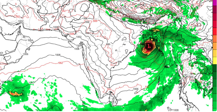
The idea that the cyclone ‘Mokha’ can hit the coast of Bangladesh on May 12 is likely to be created in the Bay of Bengal.
In a Facebook status on Wednesday (May 3), he learned that from 12 noon on May 12, the coast of North Chittagong, Notakhali and Bhola districts of Bangladesh has been on the ground. The possibility of hitting the vortex is there.
In his Facebook status, PhD researcher Mustafa Kamal Palash wrote, ‘The difference between the forecasting model of the weather forecast for the United States and the European Union has decreased in the last 24 hours.
In this case, the typhoon has reached the ground level of the cyclone mokha, but the difference between the two models has been 18 hours in the ground, which will now be decreasing in the coming days.’
In the last 24 hours, he wrote about the difference between two models, he wrote, ‘The significant difference that has decreased, is that the cyclone is possible on the coast of Cox's Bazar and Chittagong according to the European model, according to the model of North Chittagong, Notakhali and Bhola district according to the American model. Possibility of hitting the ground.
According to the European model, from 12 noon on May 12, there is a possibility of hitting the coast of Cox's Bazar and Chittagong coast and on the coast of North Chittagong, Notakhali and Bhola districts from 12 noon on May 13 according to the American model.’
However, the Department of Weather has not given a clear statement so far in this matter. Although the company has learned from the forecast of Tuesday, the company has come to know that the country has not made any clear statement. Two low pressures may occur in the sea this May, and there is a cyclone apprehension next week.
The forecast says that this May is the overall country in May. normal rainfall is likely. In this month in the country 1-3 days of thunder and hail with thunder and hail and 3-5 days of thunder and hail with light/moderate thunderstorms, along with a severe heat wave (40°C) in the western part of the country this month. And elsewhere in the country, 1-2 mild (36-38°C)/ Medium (38-40°C) type of heat wave may flow, along with the day and night temperatures may be slightly higher than normal in this month, the organization also knows.
Meanwhile, on Wednesday afternoon, a warning signed by weatherman Omar Farooq said that a low pressure may form in the south Bay of Bengal on May 7. The possibility of condensing in the next Samite is being observed deeply. Omar Farooq also knows that the low pressure can turn into a cyclone, but nothing specific can be said about it right now.