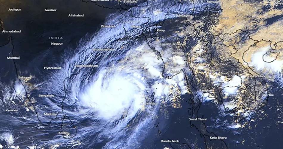
The extreme cyclone can cause a rampage of 450 km in a sphere of 450 km, because it has a diameter of 450 km.
In this case, Mokha may strike the coast of Mynmar first, which is known to be known by the weathermen of India and Bangladesh.
Meteorologist Md. Bazlur Rashid said that the diameter of the strong cyclone is four hundred kilometers. That is, there will be heavy rains in the area of more than two hundred kilometers around its center, which will be more of the storm and the flooding will be more in the country's Rakhine state.
He said, tornado hut on the right side of the cyclone and the tidal wave is higher.
The coast of Cox's Bazar will also have an impact, but Saint Martin is more vulnerable, if the flood meets the Joshter, the island of Saint Martin may go under water for some of the swamps, but it may hit the ground in the land before it hits the St. Martin.
Indian weather scientist Dr. Anand Kumar Das knows that the city will hit the ground in the middle of the Kitakpiu port in the Rakhine state of Cox's Bazar and Mitnanmar. In this case, it will hit the port area of Sitte. As a result, the port and surrounding areas may be the most affected. The international disaster warning organization Global Disaster Alert may be the most affected. The 300,000 Rohingya refugees are threatened by the 3-meter high tide of the 3-meter high tide of the 3-meter high tide of the 3-meter high-rise.
The Jharti reached the highest level of speed on Saturday (May 13) morning. It was starting to drop to 220 km. It has now started to drop below 200 km in the night.
The scientists of the organization have known that the speed of the coast will be 175 km on Sunday (May 14) afternoon. In this case, the storm will rise to the ground for several hours and the ground will be on the ground. In this case, on Monday (May 15), the force can become a deep depression.
10000000000000000000000000000000000000000000000000000000000000000000000000000000000000000000000000000000000
The eight signals mean that the port can be hit by a storm of high or maximum intensity, and the maximum continuous speed of the wind in a storm is 89 kmph. Or above it, the storm will cross the coast with the left side of the port, which means the port is cyclone, with a potential wind speed of 51-61 km per hour, but the dangerous time has not yet come to make the final preparations for the cyclone.
Meanwhile, coastal districts Cox's Bazar and their outer islands and chars will be under the 10th disaster signal. Coastal districts Chittagong, Feni, Noakhali, Laxmipur, Chandpur, Barisal, Bhola, Patuakhali, Jhalkathi, Pirojpur, Barguna and their outer islands and chars will be under the 8th Great Danger Signal.
Meteorologist Bazlur Rashid said that the low areas of the coastal districts of Cox's Bazar and Chittagong and their outward islands and chars may be flooded with winds of 8-12 feet higher than normal tides due to the influence of the anterior part of the cyclone and the air pressure difference.
Coastal districts of Feni, Noakhali, Laxmipur, Chandpur, Barisal, Bhola, Patuakhali, Jhalkathi, Pirojpur, Barguna and their outer islands and chars may be inundated by winds of 5-7 feet higher than normal tides.
On the other hand, heavy (44-88 mm) to very heavy (289 mm) rains may occur in Chittagong, Sylhet and Barisal divisions, due to heavy rainfall, landslides may occur in the Pahaji regions of Cox's Bazar, Bandarban, Rangamati, Khagrachari and Chittagong.
In this situation, all fishing boats and trawlers stationed in North Bay of Bengal have been asked to stay in safe shelter until further notice.
The name of the churnijha mokha is the name of the deo in the etimen. The name of a port famous for coffee is Mokha.